MPI+
Multidimensional Poverty Index to fight Poverty and strengthen Livelihoods in Urban Settlements


Background
MPI+ is a novel method and flexible tool that uses a robust methodology for revealing and understanding the complex realities of poverty in some of the most overlooked communities in society – urban informal settlements.
In partnership with Gerando Falcões (GF) and the MIT Sloan Latin America Office (MSLAO), DPA has built on a traditional multidimensional poverty index (MPI) by combining mixed-methods and enriching the analysis with non-traditional data sources, including:
Satellite Imagery
and Earth Observation
Very High
Resolution Imagery
Geolocated
Data
Call Detail
Records
Multidimensional Poverty and Latin America
While poverty is generally defined as living without money, the realities of those living in impoverished conditions are much more complex than economic indicators would imply. The multiple dimensions of poverty include the acute deprivations including lack of access to basic services and low living standards.
Globally, 1 in 5 people (or 1.2 billion people globally live in “multidimensional poverty” (UNDP, 2018). Latin America’s high levels of urbanization with approximately 80% of the population residing in urban areas, and inequality warrants a particular focus on socioeconomically deprived neighborhoods, commonly referred to as slums or informal settlements.
Pilot Project
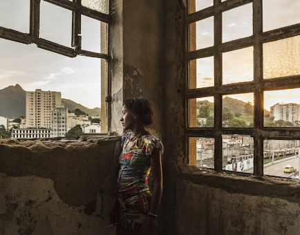
With funding from MSLAO, DPA and GF developed the beta version of MPI+ by combining local knowledge and non-traditional data sources to estimate poverty levels by dimension in two Brazilian favelas: Favela dos Sonhos, located on the outskirts of Sao Paulo, and Pedra Lisa (Morro da Providência), situated in the heart of Rio de Janeiro.
Over the course of the project, the team identified two distinct profiles of deprivation in these communities:
In Favela dos Sonhos, the population has limited access to critical services, such as healthcare, education, and transportation. This lack of access restricts their capabilities due to limited resources and opportunities.
Conversely, in Pedra Lisa, despite better access to basic services within walking distance, the population faces higher risks, both in terms of exposure to violence and exposure to climate hazards like flash floods.
The knowledge gained on the poverty dynamics in these communities will aid in the advocacy for better public policies to improve quality of life for those living on the margins of society. Policy instruments created from the outputs of this Pilot could include crisis impact evaluation tools, monitoring and evaluation tools, among others.
Ultimately, this work contributes to poverty reduction using data to produce better, more finely-grained information, both to raise awareness and to facilitate the design of more effective policies and interventions.
Potential Developments
The MPI+ Pilot Project laid the groundwork for the replication and expansion of this model to specific informal settlements in diverse local contexts. MPI+ is thus designed for flexibility and replicability, giving it considerable potential for impact at an accessible cost of implementation.
The initial results of the Pilot can be greatly enhanced with the introduction of additional data sources, including the following:
Expanding the pilot project –with the addition of these new data sources, partners, or other resources– can enrich and deepen the insights and impacts of the MPI+. Scaling –to new cities in Brazil, other countries in Latin America, or elsewhere globally– can bring the benefits of this model to the millions living outside the reach of traditional statistics and research.
Very High Resolution Imagery
The utilization of very high-resolution images would significantly improve the precision of our estimates.
Call Detail Records (CDRs)
The inclusion of CDRs in our data collection efforts would serve to confirm the usage and frequency of the identified buildings. It's essential to disaggregate this information by age and gender for a more comprehensive understanding.
Comprehensive Geolocated Data
Including geolocated data from both government sources and local entities. Ideally, this data should encompass information regarding the quality (such as school capacity in terms of the number of children or teachers) or the nature (crime data including types of crimes), and more.
Participatory Mapping Exercises
These exercises can help us gain insights into potential variations based on race, gender, or other intersectional aspects. Furthermore, they can provide valuable information about existing service provision, including residents' preferences as well as the perceived quality of these services.
Contact
For more information on the MPI+ project please contact our team at mpi.plus@datapopalliance.org