Leveraging the Crowd: How People can Contribute to Disaster Management
February 25, 2016
Data–Pop Alliance has been conducting ongoing research on Big Data, climate change and environmental resilience. With funding from the UK’s Department for International Development (DfID), we published a synthesis report evaluating the opportunities, challenges and required steps for leveraging the new ecosystem of Big Data and its potential applications and implications for climate change and disaster resilience. This report will feed into the World Humanitarian Summit to be organized in Istanbul in May 2016.This is the third in a series of companion pieces that offer insights from the synthesis report. The authors of the series attempt to go “beyond the buzz” to lay out what we actually know about Big Data’s existing utility for disaster science and for building practical resilience.
When human communities are affected by disasters, collaboration is essential to mitigating their negative impacts. There are many interesting examples of collaborative bottom-up insights building on the “wisdom of crowds” to help optimize response to disasters through humanitarian assistance. This is mostly happening through digital tools, which are playing an increasingly important role in this field. Mobile devices and open source software (e.g. Open Data Kit and Frontline SMS), enable non-expert users living in remote and/or underserved communities – especially in developing and emerging regions – to collect and share data. Additional tools allow the seamless integration of distributed data, real-time information sharing and collaborative analysis of the information produced thanks to data collected by the crowd.
In particular, spatial information is central to disaster response. This includes ‘traditional’ geographic information and aerial imagery produced by governmental organizations as well as Volunteered Geographic Information (VGI), happening as per Goodchild’s definition through “the widespread engagement of large numbers of private citizens, often with little in the way of formal qualifications, in the creation of geographic information.” Such information is often joined with other unstructured data and information released (not necessarily voluntarily) on the social web during disasters to enable the real-time mapping of impacts as well as response efforts.
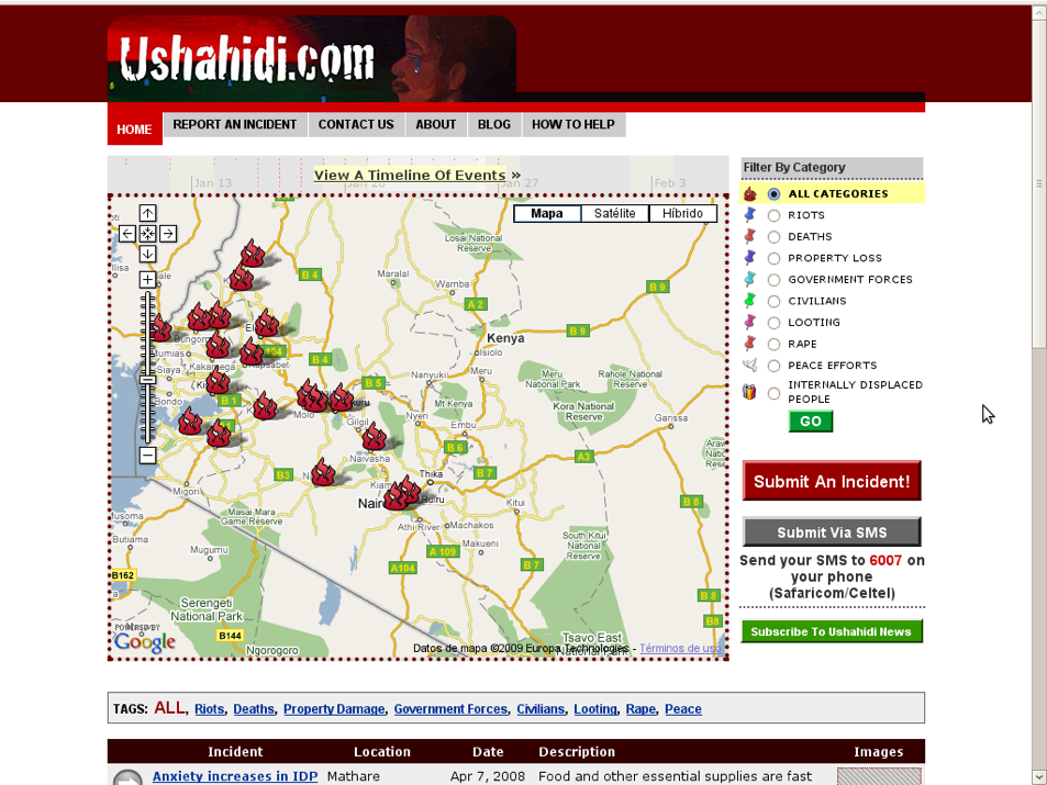
The most renowned collaborative platform is Ushahidi (meaning “witness” in Swahili), an application developed by Kenyan journalist Ory Okollah and technologist Erik Hershman to allow crowdsourced reporting of violent incidents in Kenya after the post-election crisis in 2008. An online map aggregated citizens and journalists’ reports, and more than 45,000 people used the website for contributing and/or reading reports during the first month of activity. Communities employed Ushahidi for a variety of purposes – including election reporting in Mexico, as well as to report malaria surveillance with micro-monetary incentives in India. Clearly, the platform was leveraged to track impact of various disasters, as well as for matchmaking between requests and offers for help, as in the case of Nepal earthquake in 2015.
Incidents related to 2008 elections in Kenya visualized on Ushahidi platform
Source: The Guardian
Thanks to tools like Ushahidi, the humanitarian sector is increasingly relying on the support of online volunteers who collaborate in disaster management operations. Such volunteers have been nicknamed digital humanitarians by Patrick Meier, former Director of Social Innovation at the Qatar Foundation’s Computing Research Institute. Meier headed the first crowdsourced online crisis mapping initiative to support post-earthquake relief efforts in Haiti in 2010. With the help of more than 100 graduate and undergraduate students, he used the Ushahidi platform to post geographic information retrieved from social and mainstream media. This effort catalysed other initiatives. For example, Haitian expatriates worldwide volunteered online to translate messages from Creole to English. The OpenStreetMap community developed a detailed map of Haiti’s transportation network within a few days. Digicel, a Haitian telecommunication company, set up a toll free SMS service for people to report urgent needs and their location with the help of the Thomson-Reuters Foundation, InSTEDD, and the United States Department of State. The working group collected, integrated, and verified whenever possible the geographic information to provide a free source of information to organizations and communities providing relief to the population in Haiti after the earthquake.
Map developed by OpenStreetMap community. For further information see Tim Waters’ presentation.
Source: Tim Waters, OpenStreetMap Foundation
Online tools also enable new forms of cooperation to provide support to communities affected by disasters. Volunteers can provide an outstanding contribution to disaster response that is complementary to that of standard disaster management organizations. Volunteers can help undertake tasks that require large computational power and/or a dedicated workforce – such as MicroMappers, a platform developed by the Qatar Computing Research Institute (QCRI) in partnership with the Stand-By Task Force. Volunteers from all over the world get summoned any time a disaster strikes, employing the platform to analyze Tweets and pictures to track evidence of damages as well as requests coming directly from affected areas.
Damage recognition on MicroMappers
Source: MicroMappers website, retrieved February 2016.
Digital tools involving the crowd can also have a positive impact on making disaster management more participatory, making non-governmental organizations, as well as communities from affected areas, able to participate directly to a sector which has traditionally been a top-down activity; communities were only the recipient of aid and had limited space for playing a role in disaster management operations.