In the era of Big Data, scientists and researchers have the ability to solve problems that were since unsolved and are able to apply science to issues previously untouched by data. Recently, there has been a growing application of Big Data as a source of and solution to advancing peace. The PeaceHack, a global hackathon sponsored by International Alert, brought together developers, technologists, and others from multidisciplinary backgrounds to do just that: collaborate across sectors to use Big Data and Big Data analytics to formulate ideas and solutions that prevent violence and build peace, both locally and internationally. Lasting only 36 hours, the September 2015 event took place simultaneously, through virtual connection, in seven cities around the world: Barcelona, Colombo, Derry, London, Beirut, Medellín, and Washington.
Barcelona PeaceHack CompetitionAs a partner in PeaceHack Barcelona, Data-Pop Alliance posed an interesting challenge for participants: crime prediction in Bogotá, Colombia. The aim of the task was to address potential opportunities in crime prediction modeling to promote public safety. This task presented the participants with a unique opportunity to use a combination of data on reported crime cases with large-scale human behavioral data derived from urban transportation data in order to predict crime hotspots. The value of this project was well received by the hackers—the Data-Pop Alliance Bogotá challenge was one of the three (out of ten) topics that was chosen to be analyzed during the event in Barcelona.
Parcero Team Top 3The Parcero team at PeaceHack Barcelona attempted to address the Data-Pop challenge by analyzing large-scale human behavioral data, specifically crime data records and traffic data in Bogotá. Two developers, one entrepreneur, one architect, and one researcher composed the five-person Parcero team. Team members had access to hourly data on crimes (from the police) and transport (from Transmillenum). Through analysis of this data, they tried to understand if and how public transportation affects crime. With the advantage of many backgrounds, Team Parcero came up with a very innovative idea concerning the use of crime and transportation data for urban planning. Nowadays metropolitan areas are expanding rapidly and presenting a great challenge to crime monitoring. In order to create safe and livable cities, engineers and architects should take advantage of the huge amounts of geo-location data available. In this way, data can serve as a vision for the future to assist in helping people decide how buildings can be re-designed, planned, and developed in order to make safe places in the city.
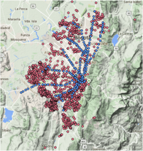
Two findings on Crime and TransportationTeam Parcero found a crucial trend while analyzing the available data: crime was concentrated in areas that are far from the transport lines. This is well visible in Figure 1, where blue points are metro stations and red points are places where crimes had happened in Bogotá. It is clear that, excluding the city center, the highest concentration of crimes is located where there is not public transportation.
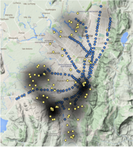
A second interesting discovery was made when trying to confirm the idea that crimes happen more frequently in areas far from public transportation. Team members found that at the end of the workday (around 5-6pm) when people are traveling home, there is more crime. This information helped the team better understand their findings and confirmed the common belief that individuals are more prone to crime after dark. Figure 2 shows not only that crime was indeed happening away from transportation, but it was happening mostly at the end of the workday. Each yellow point represent one geo-located crime, while the black circles cover areas with the average presence of crime, calculated from one year of records.
Using Big Data for PeaceThe PeaceHack and the information gathered about Bogotá’s crime trends helps to promote discussions around the analysis and future use of large-scale data and to extract meaningful recommendations for urban crime and violence reduction. The hackathon also stimulated further questions about the data and analysis gathered from Bogotá. For example, further analysis could investigate how the types of crimes change during the day or how the flow of people through transportation hubs affects the presence of crime by analyzing the number of people inside each station at a given time. The event demonstrated the impressive value of Big Data and how it can help people create solutions to build peace all over the world.
